 |
| Just like Kerala, Goa's waterways is serviced by many RORO ferries. However, what makes Goa more unique is their ferry service is free to all on foot passengers and cyclists! Taking advantage of the free service, we took the ferry from Panaji Ferry Terminal to Betim Ferry Terminal, hence saving some leg power across the busy Mandovi Bridge In photo here is Reis Margos Fort |
 |
| On Betim - Verem - Saligao Rd @ https://maps.app.goo.gl/tQLCiBryFpUEQhhL7 |
 |
| On Betim - Verem - Saligao Rd |
 |
| Reis Magos Lighthouse @ https://maps.app.goo.gl/yQSCCPgpXEfdatyY8 |
 |
| Reis Magos Church @ https://maps.app.goo.gl/BhgJjDWYu9kCguVv9 |
 |
| The Fort's walls can be seen from this coastal road @ https://maps.app.goo.gl/UTNqQWEYzp6G1CcQ7 |
 |
| Rocky Beach @ https://maps.app.goo.gl/uHgBSCeSQAKxvv2BA |
 |
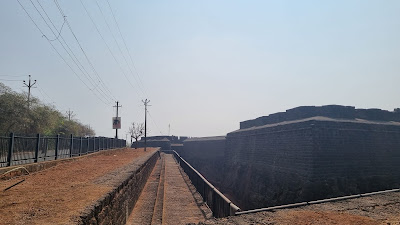
| Fort Aguada and the moat |
 |
| Fort Aguada |
 |
| Fort Aguada Lighthouse, located within the Fort |
 |
| Aguada Lighthouse located within the The Ministry of Ports, Shipping and Waterways which is next to the Fort. |
 |
| Fishing activities and water sports on Nerul River @ https://maps.app.goo.gl/uiG7NGvQRMFhWXSL8 |
 |
| Candolim Beach Road |
 |
| Aguada - Siolim Rd @ https://maps.app.goo.gl/5xLqQnvJ8Mo8K8zn7 |
 |
| St Anthony Chapel on Aguada - Siolim Rd |
 |
| Baga Bridge @ https://maps.app.goo.gl/ag3vnFtrcUSQ8P5i7 |
 |
| Saude SaibiniChem Mondir @ https://maps.app.goo.gl/1UGp43kumooKM1YV8 |
 |
| Chapora Fort. |
 |
| One of the towers of the Fort |
 |
| The Fort, located on a hill, comes with a high vantage point. |
 |
| It was not easy to visit the Fort. From the car park area, we have to barge through a parade of stalls on a paved slope. Then there were about 100-120 steps to climb to reach the top |
 |
| Chapora Jetty @ https://maps.app.goo.gl/BHvgmpNYwAWcerCe8 |
 |
| Teacher's College Students at dress rehearsal outside Penha de Franca Church |
 |
| Inside the church |
 |
| The church grounds. After this we returned to Panjim to shop for cashew nuts before returning to the hotel. Later we took a walk out for dinner at Sheetal Pure Veg Restaurant |
No comments:
Post a Comment