 |
| At the border between Italy and Slovenia. The border is marked by the crude line separating the gravel section (Italian side) and the tarmac section (Slovenia side) |
 |
| Gearing up at Hotel Roma |
 |
| U turn! The route leads to a flight of stairs which makes it hard for us with bikes, hence we had to back track! @ https://maps.app.goo.gl/jTF84DhGK5cmFD196 |
 |
| The flight of stairs as per Google streetview. |
 |
| Via Commerciale with Sailing Yacht A in the background |
 |
| Via Commerciale |
 |
| Via Commerciale @ https://maps.app.goo.gl/yHLiLiiGsJSMjCiT9 |
 |
| Getting out of Trieste. 3.9 km of the first 4.7 km from our hotel to Localita Banne, requires pushing up very steep slopes! Average 11% grade hill. |
 |
Terrazza Bellavista "Conconello-Ferlugi" at 10.00 am @ https://maps.app.goo.gl/yuCt6ehGhGgtZdos8 A high vantage point with a fantastic view of Trieste, Gulf of Trieste and Slovenia. Note Sailing Yacht A can be spotted on the right |
 |
| Sailing Yacht A |
 |
| Owned by Andrey Melnichenko, the yacht was seized by Italian authorities on 12 March 2022 due to EU sanctions against a number of Russian businessmen as a consequence of Russia's invasion of Ukraine. It was anchored at Gulf of Trieste when we were there and still remain there at publishing date! |
 |
| Via della Bella Vista @ https://maps.app.goo.gl/n5t6aHuwuZjGNicq9. This was almost at the highest point of our climb to get out of Trieste... |
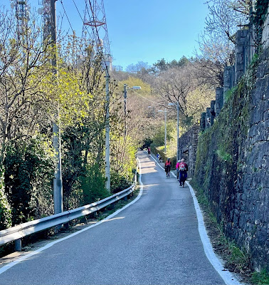 |
| ...then it was rolling downhill most of the way (with the exception of the telecommunication tower) to the entrance of Localita Banne @ https://maps.app.goo.gl/j8veHHnBBwzzxLQp7 |
 |
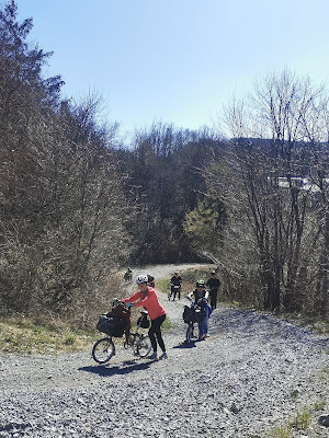
| Midway through the 1.1 km gravel route which makes up Localita Banne / Trebiciano. Note the gravel is the size of ping pong balls |
 |
| Coming to the end of the 1.1 km gravel route which makes up Localita Banne / Trebiciano at 10.45 am @ https://maps.app.goo.gl/NMdcrfNEH7qzkah29. Thankfully it is mostly downhill but fearfully, most of the gravels are the size of ping pong balls! |
 |
| The start of Localitta Banne as shown on Google streetview. Note the signboard which shows it is a bike route. On this day, it finally dawned on us most bike routes in Europe are gravel routes...oops! |
 |
| On the viaduct. Below is Route RA 13 @ https://maps.app.goo.gl/cb2T5DXJKEJFXKfB6 |
 |
| Backlanes and alleyways of Trebiciano @ https://maps.app.goo.gl/ceeXxuNKkAEy5TsU9 |
 |
| Backlanes and alleyways of Trebiciano |
 |
| We wade our way through the housings of Trebiciano to the start of this bicycle route, Localita Trebiciano @ https://maps.app.goo.gl/Ya9VCbWi1VNyDJ1Y7 Most of this route is on tarmac until Societa Adriatica di Speleologia. After that it continued in gravel up to the Slovenian border |
 |
| At the border between Italy and Slovenia @ https://maps.app.goo.gl/jjV3oYJtkWcdFy177 |
 |
| At the border between Italy and Slovenia at 11.15 am |
 |
| The bike route continues into Orlek. In Orlek, it then merges with Orleska cesta which is a low traffic route. Here is the junction to Sezana @ https://maps.app.goo.gl/AH3zosREBBEowTeE9 |
 |
| Lunch in Sezana at 12.30 pm. At this point, we had only done 13 km. Some were even considering taking the train from Sezana to Postojna! |
 |
| We used the side entrance so we could park and sit near our bikes @ https://maps.app.goo.gl/kb1LticRLEo7VQGg9 |
 |
| Back on the road after lunch at 1.28 pm. On Route 445 between Storje and Senadolice. |
 |
| Back on the road after lunch. It was getting worrisome. There was a gradual but very long climb and nobody seems bothered to cycle. Spurred by one another, everyone chose to push their bikes instead! |
 |
| Dolenja Vas @ https://maps.app.goo.gl/ESHqZHCwRrXxQavW7 This was the start of the much anticipated 4 km climb over the mountains, 3.7 km of which is gravel. |
 |
| Midway in Dolenja Vas @ https://maps.app.goo.gl/17kfbBrPfk444qV1A. Note the highway E61 in the background |
 |
| Midway in Dolenja Vas at 3 pm. At this point, Kenny and Alan were shuffling their legs, walking ever so slowly. Gerard was asking for an apple break and Claudine was beginning to loose her nerves! |
 |
| We are that red dot, surrounded by mountains!!! |
 |
| Getting closer to E61 with Plesa Peak in the background |
 |
| Time check 3.30 pm |
 |
| Spot the red dot! |
 |
| Spot Nanos transmitter on Plesa Peak, a popular hiking ground in Slovenia. The peak is measured at 1262 m |
 |
| Going under E61 |
 |
| View from below E61 |
 |
| E61 |
 |
| We are now higher than E61. The trail on the right is where we will head to after our apple break to get to Razdrto town. |
 |
| VT taking the photo from the start of the trail that will lead to Razdrto town. The wider gravel path to the left is where we will stop for our apple break |
 |
| Not an easy task |
 |
| Right after E61, we took a break at this grassy knoll. Gerard finally got his apple break. Some others took the opportunity to water the grass. Meanwhile, Claudine and VT had a deep discussion and finally decided to change the route. Visits to Predjama Castle will have to be cancelled today. We were to ride directly to our hotel in Postojna instead! |
 |
| Senozece trail right beside E61 and Plesa Peak @ https://maps.app.goo.gl/nXsGZSvZEG5kvR547 This is our highest point today at 705 m |
 |
| By far, our toughest day on the entire trip! |
 |
| Senozece trail, the other side of the mountain. So thankful to see civilization |
 |
| Finally out of the woods! Razdrto town in the background @ https://maps.app.goo.gl/ivSmX65NvtfUmy8j6 |
 |
| Better moods when we see a bike lane |
 |
| The sign we have been waiting for! |
 |
| Victory dinner |
 |
| One of our best meals on CSI. Prices in Postojna is so affordable |
 |
| Great food at Avio Pub @ https://maps.app.goo.gl/wpB86XrZqkmqStLm7 |
Photo credits :
Mindy
Gerard
-------------------------------------------------------------------------------------------------------------
Vila Lemic, Postojna, Rakitnik 30, 6258 Prestranek, Slovenia @ https://maps.app.goo.gl/ootob4BZtxsJ6nHAA


No comments:
Post a Comment